GeoDa & PySAL Impact
Spatial data science is an interdisciplinary field that develops and uses scientific concepts, methods and tools to analyze geographic data in order to gain insights related to location. CSDS seeks to advance spatial methods for area data and implement them in open spatial computational tools for research and education, such as GeoDa and PySAL's spatial econometrics package spreg. Building on Luc Anselin's 40-year track record in this field (and 20 years by his team), our aim is to go beyond academic prototypes and create software that is widely used by researchers and educators. This page highlights some of these broader impacts.
This CSDS priority area is led by Luc Anselin, Xun Li, and Pedro Amaral.
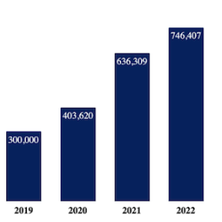
Over 3/4 Million Views of Recorded Lectures
Views of Dr. Anselin’s recorded lectures on our YouTube channel have grown exponentially from 71,000 in 2017 to 170,000 in 2018, to over half a million in 2021, and to three quarters of a million in 2022. UChicago students who were enrolled in Dr. Anselin’s Introduction to Spatial Data Science course also often use these recordings to review class materials.
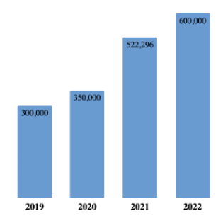
Growth in GeoDa Use
GeoDa, CSDS’ flagship open source software program for spatial analytics, remains popular among faculty and analysts, as illustrated by consistently high and increasing key performance indicators: The number of Geoda users increased from about 200,000 in 2017 to 250,000 in 2018, 350,000 in 2020 and 630,000 in 2023. Similarly, the number of Google Scholar references to publications referencing GeoDa jumped from 7,600 in 2017 to over 9,000 in 2019 and 17,700 in 2022. The average number of monthly visitors of the GeoDa website remains steady at 12,000, with larger jumps during major new software releases.
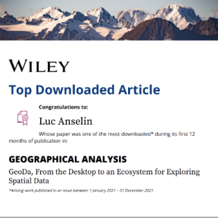
Growth in GeoDa Citations
The large number of citations of Luc Anselin’s research has been increasing steadily every year, from about 67,000 in 2019 to over 95,000 in 2023. His recent article in Geographical Analysis, co-authored with Xun Lin and Julia Koschinsky of CSDS, was the top downloaded article in Geographical Analysis, the leading journal in the field of geography.

PySAL spreg Equally Popular
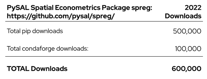
Luc Anselin and Pedro Amaral manage PySAL’s spatial econometrics package spreg. Like GeoDa, spreg has also been downloaded 600,000 times:
 THE UNIVERSITY OF CHICAGO

